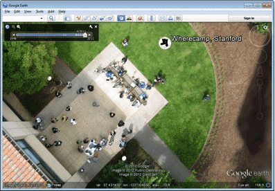
Google already offers one of the best repository of Earth’s images online. However, it is always trying to expand this repository. Now, Google has devised a rather unique way to do so. It has taken images from kites and balloons and has now added these images to the online repository of Google Earth.
These images come from The Public Laboratory for Open Technology and Science. It is an organization which aids in online mapping by furnishing grassroot exercises to that end. It’s kind of open-source, so that citizens themselves are also able to contribute to the archives of The Public Laboratory.
In fact, you can get aerial images of your own. The Public Laboratory offers prospective buyers a DIY balloon mapping kit. All you have to do is hitch along a digital camera and let the apparatus go into the starry skies and snap at the most amazing views.
It can get hard for amateur photographers at times since bringing images into a sequence can be quite laborious. To aid in this, there is a software tool which helps the users stitch together the images they have taken in a meaningful sequence. The images are brought together into a single ‘georeferenced’ image.
Google has been actively expanding its repository by adding images from the archives of The Public Laboratory. This essentially means that you can add your own images to these archives and who knows, Google may even select them as Google Earth images.
[ttjad]


