Magellan’s eXplorist Pro 10 does GIS data collection for $700 and makes Google maps green with envy.Magellan’s strength is not only in our innovative developments in GIS/GPS hardware solutions, but our strategic partnerships with some of the world’s leading technology companies and their customers, keeping an accurate GIS database up-to-date can be a challenge. Magellan offers rugged, accurate and affordable GPS hardware solutions for mobile GIS Data Collection…………

|
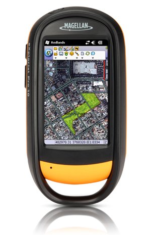
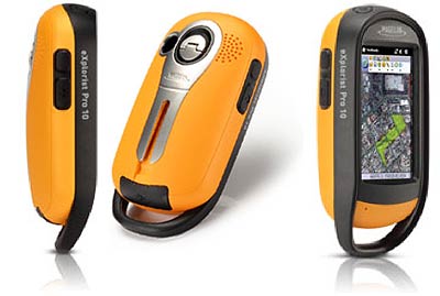
Magellan, a pioneering GPS brand announced it’s re-entering the GIS market with the eXplorist Pro 10, a rugged, lightweight and waterproof GPS handheld device specifically designed for GPS/GIS data collection.Featuring a vibrant 3-inch, WQVGA transflective color touchscreen, 533MHz processor and 128MB RAM, the eXplorist Pro 10 packs the power needed to work with maps and large data sets into a compact-handheld form factor. It comes with 4GB of onboard storage and is expandable with up to 32GB via microSDHC card slot, enabling large data sets such as aerial photos to be loaded easily.With its rugged IPX-7 waterproof casing, the lightweight eXplorist Pro 10 is the ideal GIS data collection handheld device for GIS professionals seeking to collect GPS/GIS data. The Pro 10 can deliver 3 to 5 meters accuracy in real-time using its internal GPS receiver or work with a supported Bluetooth enabled GPS receiver to achieve sub-meter or 1-3 meter accuracy.
|
“Rugged environments, reliability and durability are today’s main challenges for GIS professionals,” said Sunnie Tsai, Sr. Director, product marketing for Magellan. “With flexible GPS accuracy options, built-in Bluetooth wireless technology and a high resolution camera, the Pro 10 handheld enhances productivity at a very affordable price.”Built-in Bluetooth wireless technology enables users to connect laser rangefinders, barcode scanners and other Bluetooth-enabled devices for convenient cable-free solutions.Added features to help record data include a built-in 3.2 mega-pixel camera to capture geotagged photos and video and an on-board voice recorder to enable hands-free note taking. The Pro 10 also includes a 3D compass, pressure altimeter and barometer. It can run up 15 hours on two standard AA batteries.The palm-sized handheld is powered by the standard Windows Mobile v6.5 operating system. The Pro 10 is specifically developed as an open platform to run powerful GIS data collection programs such as ESRI’s ArcPad 10 as well as a wide range of other Windows Mobile data collection software programs.The eXplorist Pro 10 is now available through Magellan’s GIS Distribution Channel for an MSRP of $699.99.
|
[ttjad keyword=”general”]