Many people on the East Coast are worried about Hurricane Earl, and this Labor Day the strong winds are sure to wreak havoc on large areas. The President has declared a state of emergency for North Carolina, and FEMA has deployed teams to North Carolina, Massachusetts, Rhode Island, Connecticut, New Hampshire, Vermont, and Maine. So you will want to keep track of the hurricane’s progress.

Here are some resources to kickstart your tracking:
Government Resources
The National Weather Service

Get your weather warnings and advisories right from the source on top of a color-coded map. You can also use the site to check in on where Earl is likely to hit and whether or not hurricane force winds are probable in your area.
NOAA’s nowCOAST
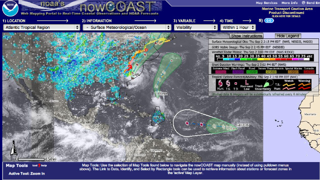
Make a customized, real-time map using NOAA data. Decide what location, information, and time you’d like to view and what data layers you’d like to activate, and nowCOAST will make a map for your request. This is a great tool for people who actually know something about weather, but it can leave the beginner hurricane tracker a bit confused.
NASA Earth Science Office
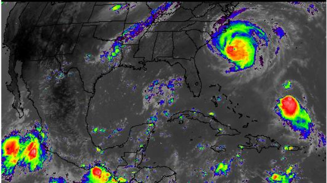
See what the hurricane looks like from outer space by taking a look at the latest satellite pictures direct from NASA’s Earth Science Office. The site offers a number of different satellite views, include infrared and water vapor readings.
Weather Media Resources
MyFoxHurricane.com
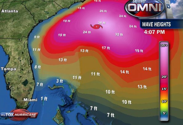
Very helpful for connecting with other hurricane tracking nerds, this dedicated hurricane website from MyFoxTampaBay and the FOX Network hosts a live chat in addition to its other hurricane resources. Interesting maps include the hurricane’s predicted path map, the wave height near the storm and a radar map that zooms in on the Outer Banks.
The Weather Channel
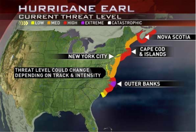
The Weather Channel’s Hurricane Central allows you to view where Hurricane Earl has been and where it’s projected to go. There are also separate maps for hurricane advisories, tropical storm advisories, wind speeds and wave heights; the site also has satellite maps for specific regions. The maps aren’t as flashy as some of the other sites on this list, but they are very easy to read and understand.
AccuWeather.com
If you want to see what Hurricane Earl looks like – and we’re not talking radar – watch this footage taken from directly above the eye of the storm. These brave NASA pilots apparently let an AccuWeather videographer on board. Hopefully this is as close to Earl as you will get.
The site’s frequent video coverage of Hurricane Earl is also a great resource.
Google Maps Mashups
Ibiseye
Ibiseye puts the storm’s history, projected path and at-risk areas on one Google (![]() ) map. It’s especially useful for finding at what time and with what intensity the storm is expected to reach a specific point. A graphical synopsis of the storm’s winds, pressure and wind field is also available.
) map. It’s especially useful for finding at what time and with what intensity the storm is expected to reach a specific point. A graphical synopsis of the storm’s winds, pressure and wind field is also available.
StormAdvisory

Another Google Maps-based resource, StormAdvisory plots Hurricane Earl’s actual path and wind speeds as well as its projected path and wind speeds.
Weather Underground

The tropical weather section of Weather Underground includes radar, satellite, wind and forecast maps. The stand-out feature, however, is the site’s trademarked “Wundermap,” on which you can choose layers of information to display.
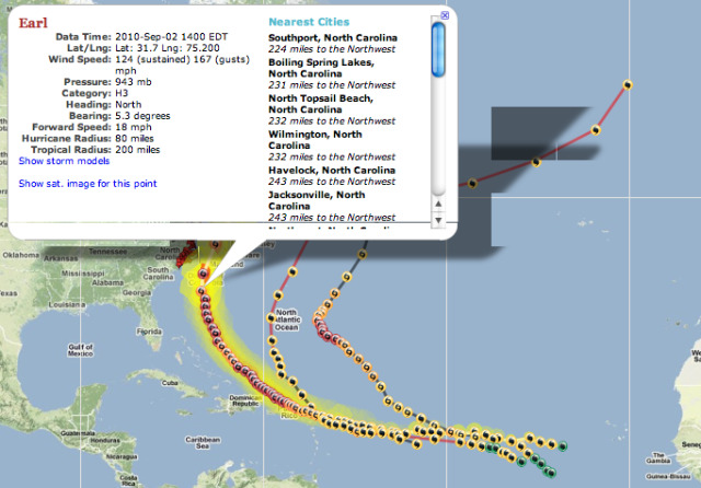
Stormpulse: A Hurricane Tracking Dashboard

Stormpulse is all you need to track Hurricane Earl’s vital stats. The dashboard displays every the essential detail, including current category, wind speed and movement, on one screen. You can switch the map to radar or satellite and select a point on the map to calculate its distance from the hurricane.
Mobile Resources

- The Weather Channel App for iPhone (
 ) or BlackBerry ()The free version of the Weather Channel’s app for both iPhone and BlackBerry will alert you to weather advisories in your area and check in on the current forecast. The iPhone version comes with an updated local video forecast as well. If you want more from your weather source, a $3.99 iPhone version of the app comes with access to an entire video center and a database of beach condition reports. The Weather Channel also claims this is the only weather app with animated future radar.
 - Hurricane iPhone AppAnything a storm tracker could want: animated satellite and radar, computer models, NHC bulletins, forecasts, your distance from each forecast point and all the vital stats (including wind speed, direction and pressure). You can keep this $1.99 app on your phone after Earl has passed for the latest updates from government hurricane centers.
- Hurricane Wallpaper Android AppDownload this $0.99 Android (
 ) app, and you’ll never be without your weather map. You can keep the current National Hurricane Center’s Atlantic Tropical Cyclone Activity image up on your phone as your wallpaper.
 - MyFoxHurricane iPhone AppThe resources of MyFoxHurricane.com (as discussed earlier in this post) in a $3.99 iPhone app. Get access to breaking news and videocasts from the site as well as radar and satellite images. You can also look at past hurricanes in your area to see how Earl compares.
- Hurricane Hound Android AppThis Android app shows the storm’s current position, projected storm track and storm warnings on a Google map. It also lets you know how far away you are from the storm at any given moment. And it’s free, which we like.
- AccuWeather.com iPhone AppNot fancy but still free, AccuWeather.com’s iPhone app will alert you to weather advisories in your zip code. Aside from accessing the usual web forecast, you can also access video forecasts for your area.
- Hurricane Central Web App Tired of downloading apps? Hurricane Central is a bare-bones mobile site for hurricane information. It pulls maps, advisories and other hurricane announcements from the National Hurricane Center.
Twitter Resources

- @VisitNC: The official tourism site for North Carolina, the state which is predicted to take the brunt of the blow, is tweeting travel conditions and beach closings as well as posing some interesting questions, such as, “What message in the sand would you write for Hurricane #Earl?” It’s good to see them keeping a sense of humor.
- @CNNweather: Breaking news from CNN, including new weather warnings and forecasts.
- @breakingweather: AccuWeather.com’s Twitter () feed for breaking news (including hurricanes).
- @TWCBreaking: If you prefer the Weather Channel to AccuWeather, this is its very similar breaking news Twitter feed.
- @MyFoxHurricane: Twitter resource from Fox’s dedicated hurricane website (mentioned above).
- @hurricanes: The Science News Blog’s hurricane coverage, which focuses on the Atlantic region.
- @wunderground: Severe weather warnings and updates from Weather Underground.
- @stormpulse: Frequent storm updates and advisories on tropical storms and hurricanes.
- @NASAHurricane: NASA is equipped like no other organization to cover hurricanes (e.g., they’re able to fly directly into the eye of a hurricane). Follow this feed so you don’t miss their updates.
- @hurricanetrack: Let someone else track the hurricane in person. Get live video streams from HurricaneTrack.com.
Source: Mashable.


