The Devastating earthquake that struck the capital of Haiti, Port-au-Prince, this week may have made current maps suddenly out of date, obstructing relief and rescue efforts, but earth observation satellite images are proving to be helpful by providing updated views of how the landscape and the infrastructure have been affected. You can reveal the earthquake images through Google Earth.
You can now get a satellite’s-eye view of the devastation in Haiti with Google Earth. Google worked with satellite imaging company GeoEye to put together a map layer file that provides up-close views of the wreckage of government buildings and more in the Haitian capital city of Port-au-Prince.
To view the images you can either download the KML file to add an image layer to Google Earth or you can use the Google Earth browser plug-in to view the images on Google Maps. Google says it will automatically update the Haiti layer as more data and images become available, but Google Earth users only need to download the KML file once.
Following the event, the French Civil Protection authorities, the Public Safety of Canada, the American Earthquake Hazards Programme of USGS and the UN Stabilisation Mission in Haiti have requested for satellite data of the area from the International Charter on ‘Space and Major Disasters’.
The initiative, referred to as ‘The Charter’, is aimed at providing satellite data free of charge to those affected by disasters anywhere in the world.
To meet the requirements of the rescue teams in Haiti, Very High Resolution imagery is needed from both optical and radar sensors.
Currently, data are being collected by various satellites including Japan’s ALOS, CNES’s Spot-5, the U.S.’s WorldView and QuickBird, Canada’s RADARSAT-2 and ESA’s ERS-2 and Envisat.
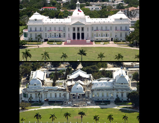
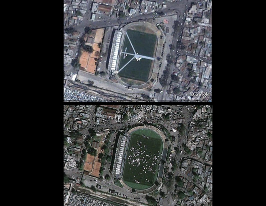
Comparison of the maps from before and after the event allows areas that have been hit hardest to be distinguished and identify passable routes for relief and rescue workers.
Additionally, they can help to identify areas which are suitable for setting up aid camps where medical support and shelter can be provided to people.
Watch Photos of Haiti Before and After the Earthquake
Haiti Earthquake in Google Earth
Source: Eweek.com, ABCNews.go.com, HaitiNews.net