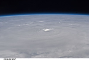
As hurricane Earl is getting ready to hit the US East Coast, NASA is watching from the skies, using its large high tech fleet of aircraft and satellites. Yesterday Earl was a category 3 storm with 125 mph winds. But in a single day, it’s reached category 4 140 mph winds.
NASA scientists are flying airplanes into this swirling mass, measuring the hurricane’s wind speeds, precipitation and more. As part of NASA’s GRIP program — Genesis and Rapid Intensification Processes — a NASA DC-8 flew through Earl’s eye six times as the hurricane intensified from a Category 2 to a Category 4 storm.
Meanwhile, an ISS crew member used a digital camera with a 50mm lens to take the above photo, from a much safer distance.
Source: Popular Science.


Hopefully everyone will ride this storm out safe and sound. Being located in South Florida, we certainly are familiar with hurricane preparations. Here’s a brief article on how to avoid data loss.
http://ezinearticles.com/?Data-Loss-and-Preventative-Measures-to-Avoid-It&id=90914
http://www.ecodatarecovery.com
What matters most to me is being expert to withdraw my winnings without a contradict, as [url=https://onlinecasinosrealmoneyca.com/ ]Online casinos real money[/url] and this site delivers on that promise. The withdrawal process is obvious and surprisingly wild compared to most competitors. I also appreciate the fair tip terms which are unoppressive to traces in the account dashboard. The purlieus feels professional, win, and honest. I’ve recommended it to a scarcely any friends already because it’s rare to chance such a principled train driver in the industry today.
Did you grasp your body is wired to reciprocate to CBD? Every human has an endocannabinoid system (ECS) that influences mood, slumber, and immune response. CBD is unequalled because it doesn’t hold precisely to receptors like THC does; in preference to, it encourages the bulk to utilization its own endocannabinoids more effectively. It’s like a tune-up for your biological signaling, promoting efficiency and ease