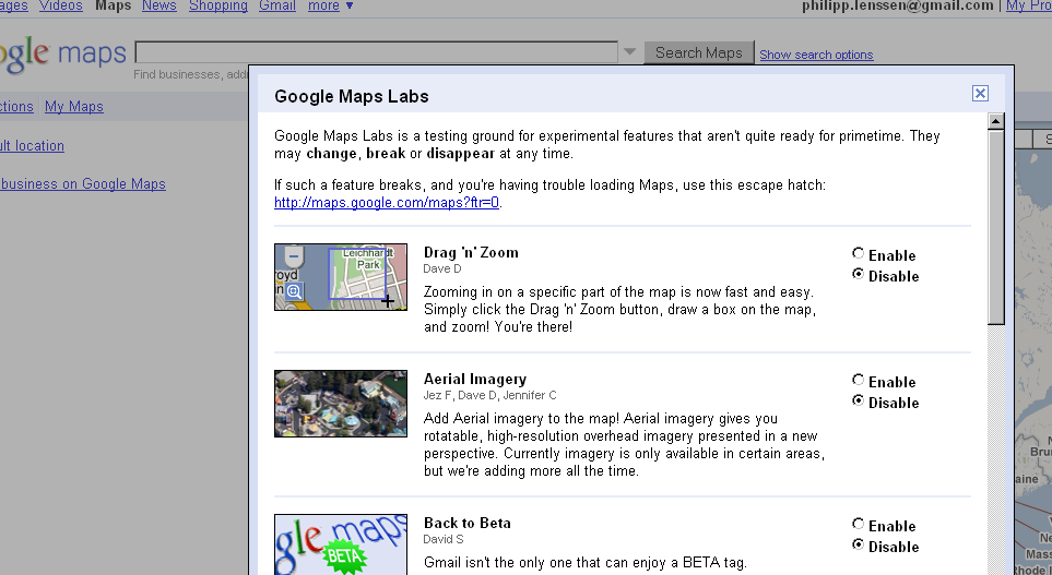
Google just added 9 new cool features in their location service application Google Maps. They features a new button named Google Maps Labs. It’s the little green vial in the top right menu. Go to Google Maps ans experience the new features.
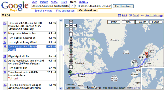
The new features that has been added are disabled by default. Click the green flask at the top of Google Maps and you get a chance to enable features like the following:
1. Drag ‘n’ Zoom – Click the Drag-and-Zoom button, then draw a box on the map to immediately zoom into that place.
2. Aerial Imagery – Available for certain areas, aerial imagery “gives you rotatable, high-resolution overhead imagery presented in a new perspective.”
3. Back to Beta – This will simply add a “Beta” icon to the Maps logo.
4. Where in the World Game – Guess the name of the country from satellite imagery.
5. Rotatable Maps – This puts north facing downwards, for instance.
6. What’s Around Here? – This will trigger a search for anything (“*”), showing the top places for a given location.
7. LatLng Tooltip – Shows the latitude/ longitude of where your cursor is positioned.
8. LatLng Marker – Drop a marker anywhere on the map, showing the latitude and longitude of that location.
9. Smart Zoom – stops you from zooming into an area if imagery is not available.
Source: Mashable, BlogoScoped
গুনে গুনে পার করা সময়
নিরুদ্দেশের পথে কালের লাগামহীন ঘড়ি
আর মাঝ রাতের শব্দহীন নিরবতা
দিয়ে যায় অনন্ত যাত্রার সংকীর্ন আবহমানতা ।
Now Officially Bangla Working
Google Latitude + Google Ocean = Real-time Fishing LBS Contents
Have you heard about Real-time Fishing LBS Contents? We have proposed this Service Model to Google over 4 years ago. Real-time Fishing LBS Contents is Location Based Service for IPTV, WiMAX, Mobile. This Service Model was created in 2002 by I&IWorld. I&IWorld's located in South Korea. As you know, there're many people enjoy fishing in the world(about 5 hundred million). I&IWorld's Real-time Fishing LBS Contents is like these.
*Main Functions*
1.The underwater topography and 3D views with fishing spots
2.Real-time fishing points tracing by GPS and angling direction guide
3.Service the real-time fishing condition about fishing place(weather, water temp, depth etc)
4.Angler Social network(such as Second Life)
Everyone knows that Google motto is, 'Don't be evil.' Is it all right? Visit http://www.koreacontent.org/weben/index.jsp, and type 'Real-time Fishing LBS Contents'. Search http://www.koreacontent.org/co/i/iiworld/index….. If you need more information, please send your email address.